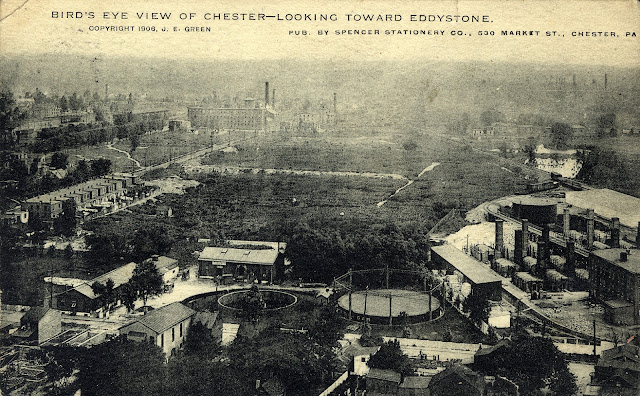
A rare postcard showing Chester in the 1920's looking toward Eddystone. I'm hoping a reader can give me a location.
Note: There are many old names in Delaware County, today and many have faded and been forgotten. When I first became interested in Delco History many of the old names drove me crazy. The locations were hard to find and understand. Below is a story of old forgotten names once used in Chester.
CHESTER’S OLD SECTIONS HAD QUEER PLACE NAMES
What
is Chester today was for the most part Chester 75 years ago. But it was also Frogpond, Powhatten,
Larkintown, Thurlow, Temperanceville, Pigeon Hill, Happy Valley, Forty Acres,
and many others. Within what are now the
city limits were these small communities and sections which all had descriptive
and picturesque names.
Frogpond
was named for, of all things, a frog pond.
Powhatten was named for old mills, Larkintown for the Larkin family and
Thurlow for the Thurlow family.
The
facility around what is now Seventeenth Street, east of Providence Avenue was
known as Frogpond. The name originated
because there was a pond populated by frogs located there during the
development of North Chester Borough from 1873 until 1877. A person who lived in that vicinity was known
by the dubious title of Frogponder.”
On
Fourteenth Street just south of the Chester Rural cemetery were located the
Powhatten Mills. The mills were operated
by the Esrey family. From the mills’
name this section of the city soon became known as Powhatten. The name Powhatten is undoubtedly derived
from the famous Indian chief of the same name.
The
Larkin family owned much of the land and resided in the section which is now approximately
the area between Eighth and Tenth Streets, and Edgmont Avenue and Potter
Street. Thus this section became known
as Larkintown.
At
Ninth and Upland Streets was a store operated by N. Larkin. In the rear there was a small carpenter’s
shop. The property at the corner later
was the home of John Larkin, ex-mayor of the city. St. Paul’s church is now located on this
site.
The
Larkins also owned the whole block between Eighth and Ninth and Madison and
Upland Streets and many other properties in this vicinity. According to a map drawn up in 1870, Charles
Larkin owned a property at the corner of Eighth and Potter Streets and there
was a woolen factory operated by the Larkins at Seventh and Potter Streets.
The
Larkin family name still is retained in this area by the Larkin Grammar School
at Ninth and Crosby Streets.
The
West End section around what is now Thurlow Street was formerly known as
Thurlow, named for the John J. Thurlow who owned a large estate here. His home, known as “Sportsman’s Hall” was
located along the river at about the point where the South Chester Tube Company
is now located.
The
old home grounds are now bordered approximately by Harwick Street, Highland
Avenue, and Second and Third Streets. It
was built about 1840 and taken down in 1869 when Third Street was surveyed and
laid out by William B. Broomall. All of
the surrounding section was then known as Thurlow and there was a railroad
station on the Philadelphia, Wilmington and Baltimore line known as Thurlow
station located there.
There
were many other section names for the city.
The section around what is now Twenty-fourth and Chestnut Streets was
known as Temperanceville. Out Providence
Road where the Governor Printz Bridge now crosses Ridley Creek were a group of
homes known as Shoemakerville.
The
section what is now East Thirteenth Street west of Providence Avenue was known
as Pigeon Hill. The section adjoining
the present site of the Aberfoyle Manufacturing Company was called Happy
Valley. The vicinity of Central Avenue
and Concord Avenue was known as Forty Acres.
The
area between what are now Third, Seventh, Ulrich and Broomall Streets was at
one time known as Perkin’s lawn. Abraham
R. Perkins owned most of the land in this area and thus the name.
Most
of these sections have long since lost their names and become merely a part of
the city with no special identity.
However, Chester still retains a few section names.
There’s
Bethel’s Court, between Market, Welsh, Second and Third Streets. This area was so named because the Bethel
Methodist Church was at one time located there.
Then
there’s Holy City, the title given to the long block of West Eighth Street
between Sproul Street and Chester River.
This area is said to be so called because of the quietness of the section. The lack of noise is accentuated by the
area’s proximity to the downtown business district.
Among
the city’s newer settlements with old names is Eyre Village. The new development was named for the Eyre
family, Joshua P. Eyre and William Eyre, Jr., being owners of the tract in the
mid-nineteenth century.
One
of the city’s most historic spots is the present site of the Baltimore and Ohio
railroad station at the junction of Edgmont and Providence Avenues and Twelfth
Street. This was formerly known as
Hangman’s Lot. In early times it was the
scene of public executions. It was also
sometimes called Gallows Hill.
The Holy City homes also had/have 'peaks' on the front roof sections that looked like steeples.
ReplyDeleteThe picture is between 3rd and 2nd at welsh st looking at harbinson - walker refractory plant at right and phila gas and electric at center. 2nd st ends at lower right under tree and houses to the right.
ReplyDelete